Brandneues

Eastern Madagascar

Fort Manda

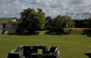
The ruin of Fort Manda is about three kilometres northeast of the coastal town of Mahavelona (Foulpointe) and can be easily reached by foot from there. Directly from the end of the town it is only half as far. A visit should take at least half a day, the entrance fee is about 3000 Ariary. Fidel, the guide and guardian …

Lesen

Akanin’ny nofy reserve

Indri

Akanin’ny nofy: The name Akanin’ny Nofy means “the nest of dreams”. The name describes this little paradise perfectly. However, the reserve is better known under its second name “Palmarium” or formerly “La Palmarie”. Location: The Akanin’ny nofy reserve is located on a peninsula in eastern Madagascar, about 60 km south of the city of Toamasina (Tamatave). From Toamasina you drive …

Lesen

Masoala national park

Masoala: Masoala means “eyes of the forest”. The national park owes this name to the Aye-Aye (Daubentonia madagascariensis), whose eyes ghostly glow like two large yellow spheres in the light cone of the torch at night. Unfortunately, night walks in national parks are currently forbidden, so that only the name testifies to this magnificent experience. Location: The Masola National Park …

Lesen

St. Marie (Nosy Boraha)

Tuktuk

The two islands St. Marie (in Malagasy Nosy Boraha) and Nosy Nato are located at the East coast of Madagascar and belong to the province of Toamasina. Especially Nosy Boraha is, besides Nosy Be, one of the most visited islands of Madagascar and has a good infrastructure. St. Marie is relatively large, around 50 km long, above two to seven …

Lesen

The big market of Toamasina

Toamasina (Tamatave) is the largest city on Madagascar’s east coast, and is home to the country’s largest port. This makes it the largest transshipment centre for spices, food and everyday goods in the area. The city has two markets, the small market (Bazary Kely) directly at the station and the large market (Bazary Be) between Rue Admiral Billard and Rue …

Lesen

Canal des Pangalanes

Canal des Pangalanes is a river of about 645 km length. The channel runs parallel to Madagascar’s east coast, sometimes only few hundred meters away from the Indian ocean. Already at the times of the Merina kings and queens in 16th century, waterways were built to link regions isolated from each other. The overland route was weary during these times, …

Lesen

Marojejy National Park

Marojejy: Marojejy National Park is one of the most biodiverse and beautiful in Madagascar, but also one of the most difficult to travel to. An “advanced paradise”! The Malagasy words maro and jejy have various meanings, including “many stones” and “much rain”, but also “many animals” and “many ancestral spirits”. Location: Marojejy National Park is located in the northeast of …

Lesen

Andasibe-Mantadia National Park

Andasibe: Formerly, this national park and the village Andasibe had the french name Périnet, which derived from French Henri Périnet, who built the train station nearby at the beginning of the 20th century. Today it is a complex of national parks wearing the Malagasy name Andasibe-Mantadia. The Malagasy name Andasibe means as much as “big camp”, which points to the …

Lesen

Madagascar’s oldest church

Kirche auf St. Marie

On the east coast of Madagascar, on the island of Nosy Boraha (St. Marie), you will find the oldest Catholic church in the country. It is located directly at the sea on the southern edge of the largest city of the island, Ambodifotatra, and thus belongs to the Analanjirofo region. Nosy Boraha came under French domination as early as 1750. …

Lesen

Ilot Madame

Museum Ilot Madame

In the east of the holiday island St. Marie (Nosy Boraha), there is a small island that is home only to a hand full of houses. Under French colonial power, it was called Ile aux Cayes, but in 1920 the French man Sylvain Roux renamed it. He called the island Ile aux Madame – island of the Madam (in Malagasy …

Lesen